South Island gold · pilot

Find the ground everyone else forgot.

Lepro reads a century of open-file exploration reports and historic newspapers, lays them over today's permits, geology and land status, and ranks the open ground worth a look. Every number is cited to the page it came from.

Onshore cells scored
155,326
Reports read page by page
138
Ranked targets, South Island
50
The Lepro map of the Hokitika district: ranked gold targets in yellow, report findings in pink, current permits in green, and a ranked target list in the side panel.

The Hokitika district in Lepro. Figures from the 18 October 2026 runs; the archive keeps growing, so later runs can reorder targets.

The problem

Decades of reports nobody reads. Ground that lapses quietly.

New Zealand's open-file archive holds a century of exploration: Mines Department bore logs from the 1920s and 30s, company reports, assay tables and hand-drawn plans. Most of it is scanned paper. It is free to download and almost nobody re-reads it.

So ground with recorded pay drops out of a permit and back onto the register without anyone noticing, and applicants choose ground on a hunch, a forum post or a weeks-long consultant's desk study.

0.69g/m³

Median value of the 98 historic drill holes and samples behind the Hokitika top ten. Almost none of that ground has been re-drilled with modern methods.

61of 551

Permit applications NZP&M rejected outright in 2025 for not meeting a basic standard. Source

NZ$3,450

Non-refundable fee for a prospecting or exploration permit application, before a single day in the field.

2024-11

When a permit over one open Hokitika target lapsed. The brief flags it: find out why before you apply.

How it works

Data, then evidence, then ranked ground, then a brief.

  1. 01 Data
  2. 02 Evidence
  3. 03 Ranked ground
  4. 04 Brief

01

Data

Today's register, the land and the rocks

Every permit, application and lapse from the NZP&M register, refreshed daily, on one map with the land you cannot touch and the geology underneath.
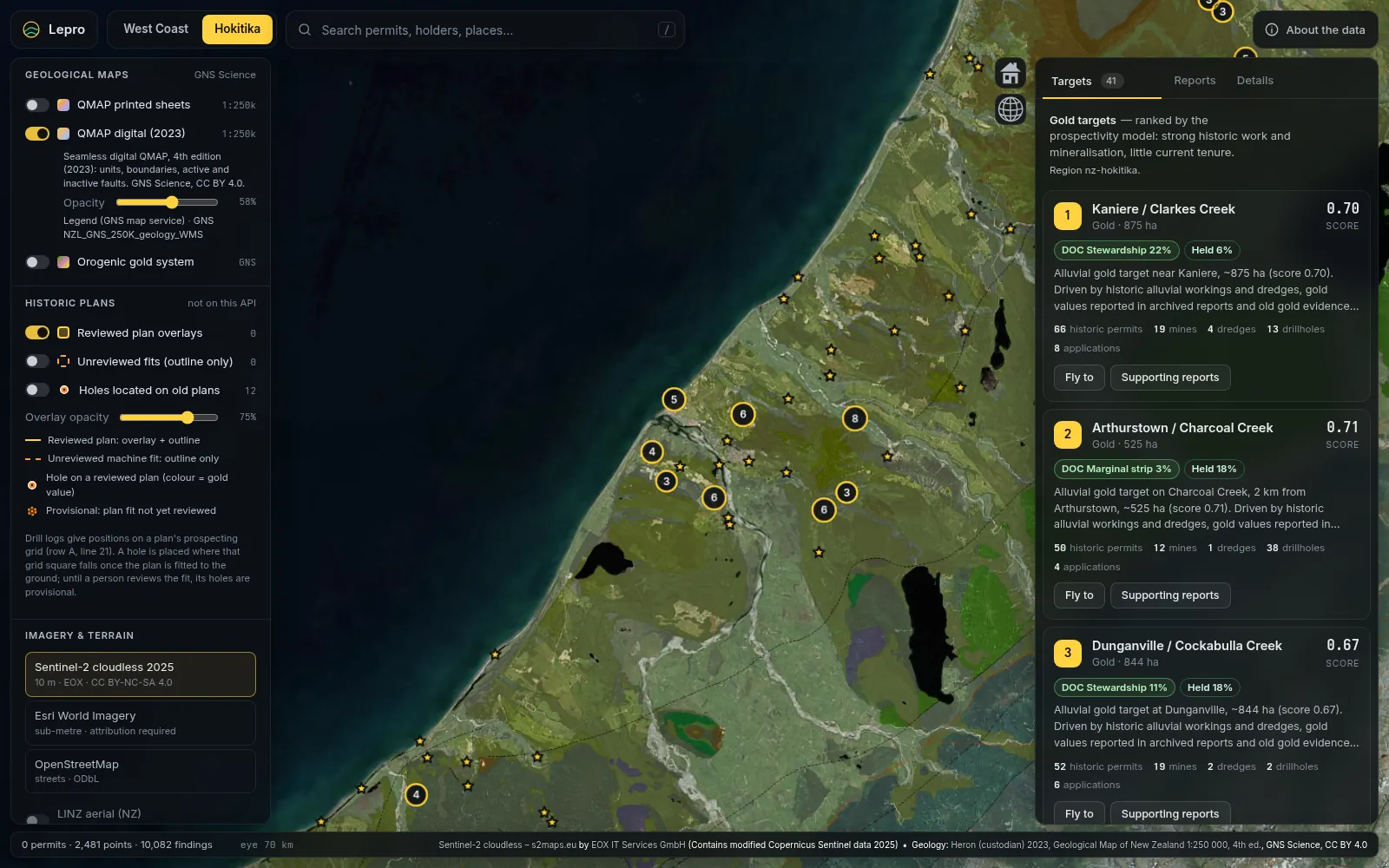
  • Current, proposed and historic permits, Schedule 4 and excluded land
  • DOC conservation land, with where an access arrangement is possible
  • GNS QMAP geology and faults, recorded gold sites, dredges and drillholes
GNS QMAP digital geology draped over the Hokitika district in Lepro, with recorded gold sites as stars and the ranked target list alongside.

02

Evidence

Every page read, every number cited

Scanned reports are transcribed page by page, and a second, independent read checks every number. Where the two disagree the page is flagged, not quietly smoothed over.
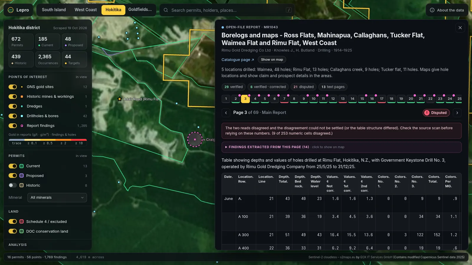
  • Drill logs, samples and workings extracted with a verbatim quote and page
  • Old units converted: pence per cubic yard at the printed gold price to g/m³
  • Historic newspapers from Papers Past located on the map, quote included
A 1925 Keystone drill table from open-file report MR1043, page 3, transcribed in the Lepro reader, with its verification status and the findings extracted from the page.

03

Ranked ground

An explainable score for every cell

A gold model scores the ground cell by cell, from 250 m in a district to 1 km across the island, and draws the best blocks into targets you can rank, filter and open.
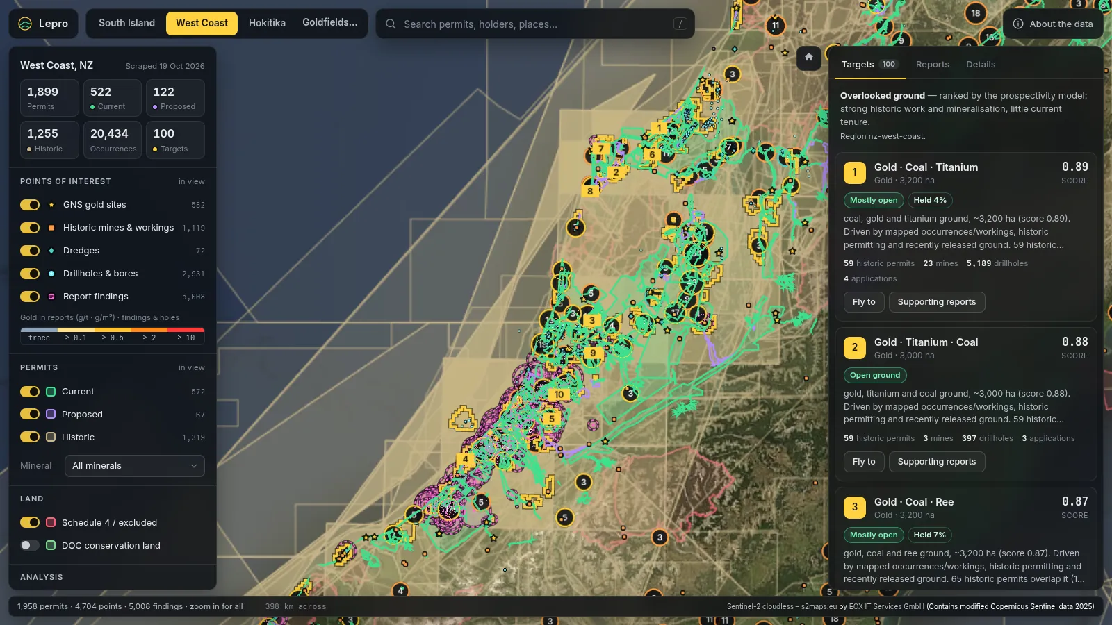
  • Each score breaks down into named drivers you can check
  • Schedule 4, national park and closed reserve land score zero
  • Where no report has been read yet, report evidence counts as unknown, not as zero
The West Coast region in Lepro with ranked targets, permits and report findings, and the target list with scores and land status.

04

Brief

A brief you can act on, and check

Each target comes with what you would need to get on the ground, written for the person who has to lodge the application.
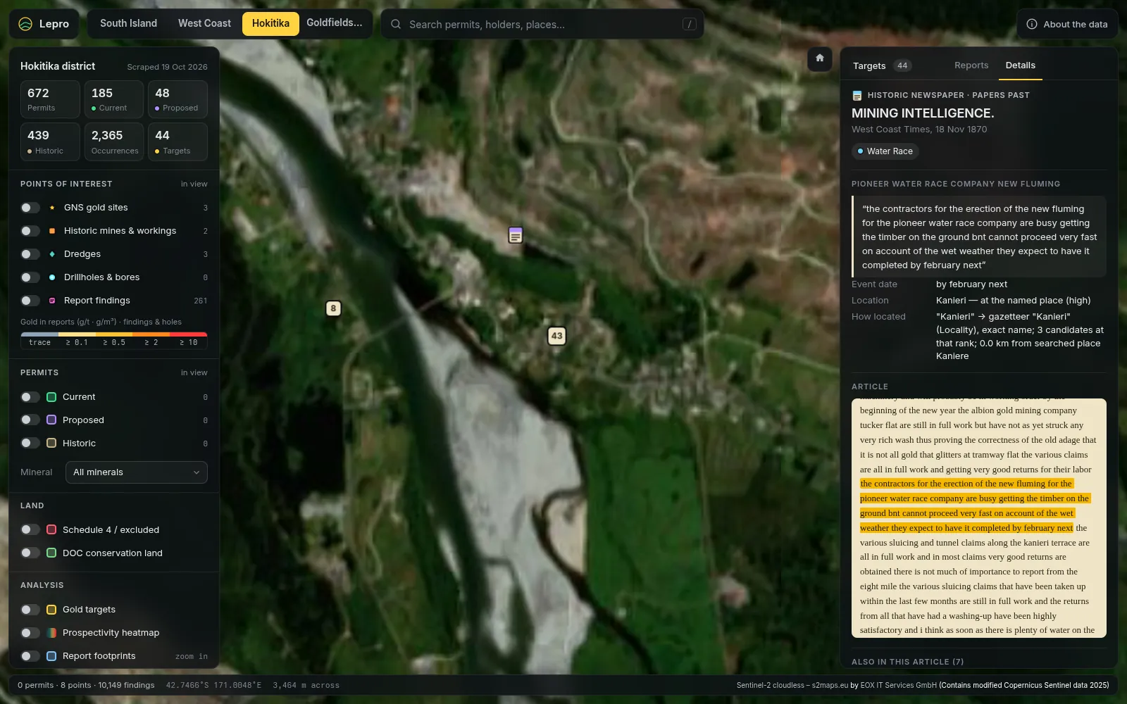
  • Land status: holders, expiry dates and other people's applications nearby
  • The permit pathway, access arrangements and consents you would need
  • A first field step, the caveats and an honest confidence label
An 1870 West Coast Times article from Papers Past in Lepro, with the quoted passage about water race fluming at Kanieri highlighted and located on the map.

Who it's for

For the people who have to decide about a piece of ground.

Prospectors and syndicates

Choose ground before you spend the application fee and a field season. See the old pay, who holds what next door, and which applications are ahead of you.

Area Gold Brief · Ground Review · Ground Watch

Small explorers and consultants

Area selection and desk studies in a day rather than weeks: every extracted grade and hole with its page image, work history by holder, GIS and CSV exports.

Desk Study Pack · Data licence

Landowners and iwi

What has been recorded under your land, who holds or has applied for permits around it, and what an access arrangement means for you. In plain language.

Landowner and iwi report

Investors and analysts

Factual evidence on a company's New Zealand permits: tenure history, prior work and results in the open-file record. No opinions on companies or securities.

Investor evidence pack

Sample brief

One target, as it appears in a brief.

This is target 3 of the Hokitika district brief, lightly trimmed. The quoted lines are verbatim from 1930s Mines Department drill logs, with the report and page they came from. Applicant names are left out here.

  • Values are historic report values, converted and cited, not resources
  • Land status from the loaded layers, with the gaps stated
  • Caveats are part of the brief, not a footnote
Ask for a brief on your area
3

Paroa / Saltwater Creek

Alluvial · 438 ha · at Paroa, West Coast

0.50score

OpenConfidence: mediumNo Schedule 4

Why

  • Model drivers (0–1): old gold evidence with little modern drilling 1.00; drilling 0.95; gold-bearing gravels 0.66; gold values in archived reports 0.46.
  • 15 gold values from old reports near it; best 1.37 g/m³, median 0.69; holes 4–12 m deep.
  • Geology (QMAP): Holocene ocean beach and river deposits.

From the archive (verbatim, page cited)

MR1092 p.10 1934 · drill log 1.37 g/m³, 7 m to bedrock

“Depth to bedrock: 24' Total depth: 35'”

MR1160 p.3 1936 · drill log 1.22 g/m³, 6 m hole

“7 | 21 " | 44·152 d. | 28·846 d.”

Land status

Essentially unheld (under 5% inside a current permit); 2 other applications within 1.4 km.

First field step

Re-locate the old drill lines from MR1160 and MR1092 on the ground, then auger or test-pit two or three of the reported pay holes to check the old values before anything bigger.

Caveats

  • The outline takes in part of Paroa itself: houses, roads and the highway are not available ground. Trim the target to the open paddocks.
  • Old drill logs use local grids; holes are pinned to the named flat, not their exact spot.
  • A permit here lapsed recently (2024-11): find out why before applying.
From the Hokitika brief, analytics run of 18 Oct 2026 (model gold-placer-orogenic 1.0.0, 250 m cells). Treat targets as places to go and look, not resources.

What a Lepro brief is not

  • Not a JORC or NI 43-101 Public Report. Not prepared or reviewed by a Competent Person, and not for publishing to investors.
  • Not investment advice. No buy, sell or valuation opinions on companies or securities.
  • Not a licence to dig. You still need a permit, access arrangements and landowner consent. Every brief says which.
Read the disclaimer

Look at the ground before you lodge the application.

Lepro is in pilot on the South Island. Tell us the area you are looking at and we will send you a brief, or create an account and order one.